We participate in projects with public institutions and private organizations. We also work on internal projects for research and continuous learning. All our projects, unless otherwise specified as contract requirement, are shared as open source projects.
Projects
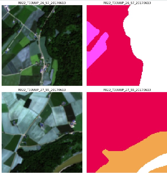
Deep Learning for Remote Sensing - Land Use / Land Cover
The aim of the project is to use a deep learning model to classify satellite images at the pixel level. In other words it implements a neural network for semantic segmentation. One application is land use and land cover. Other related tasks are change detection and satellite image time series. Deep learning models are used to address basic computer vision tasks such as image classification, semantic segmentation, and object detection applied to satellite and aerial imagery. Continuous monitoring the land cover is relevant for land management, agriculture, wildfires, land surface roughness and albedo. Once pixels of a satellite or aerial image can be mapped to a class from a LULC taxonomy it can be used to extract statistical information about the area.
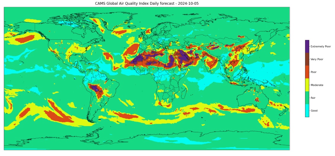
6th ECMWF-EUMETSAT-ESA Joint Training on Atmospheric Composition
A collection of Jupyter notebooks that implement algorithms for air quality classification, monitoring of NOx emissions, Model Output Statistics. (GitHub repo)
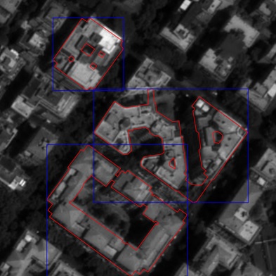
Rooftop Type Identification
Energy efficiency and renewables are two core elements of the European strategy to mitigate climate change, and even more so after the energy market disruption caused by Russia’s invasion of Ukraine in February 2022. In order to make a more informed transition to renewables and to more energy efficient buildings, the EU is collecting data to assess the actual energy efficiency of buildings in Europe and the solar energy potential of the buildings’ rooftop, in particular in urban areas.
The goal of the Rooftop Type Identification (RTI) project is to classify the rooftop type of buildings from VHR satellite imagery, using computer vision and machine learning algorithms, in order to assess the feasibility of installing solar power panels on rooftops, in particular in urban areas, and also potentially infer other building’s characteristics such as its age and change in time. The shape of the rooftop, whether it is flat, gabled, pyramidal, or other type, with additional building’s attributes, will allow a more accurate estimation of the building’s solar potential and energy efficiency at the EU scale.
Big Data Europe - Empowering Communities with Data Technologies
Microservices application deployed on a cluster of EC2 servers for the monitoring of urban traffic. This project has received funding from the European Union’s Horizon 2020 research and innovation programme. (GitHub repo)
Fusepool Linked Data Platform
A platform for data integration based on Semantic Web technologies. This project has received funding from the European Union’s FP7 research and innovation programme. (GitHub repo)
Open source projects
Deep Learning for Earth Observation
Land Use and Land Cover Classification using a ResNet Deep Learning Architecture (GitHub repo)
Deep Learning with TensorFlow
Jupyter notebooks with notes and examples from the book Deep Learning with Python, 2nd Ed. by François Chollet (GitHub repo)
Geospatial Data Science
Jupyter notebooks about geostatistics and remote sensing based on the book Geoprocessing with Python by Chris Garrard with examples using public datasets:
- Coordinate reference systems
- Raster and vector data
- Spatial reasoning
- Sub-setting
- Mosaicking
- Spatial interpolation
- Pan-sharpening
- Local, focal, and zonal analysis
Finstat
Jupyter notebooks about financial time series and portfolio optimization. (GitHub repo)
Digital Image Processing
Jupyter notebooks about digital image processing using Python (GitHub repo)
Numerical Methods for Scientific Applications in C/C++
Numerical methods in C/C++
- Floating point arithmetic
- Random walk on a square lattice
- Connected components
- Markov Chain Monte Carlo
Covid-19 Data Visualizations
Data visualization of the covid-19 pandemic using the data collected by the Johns Hopkins Center for Systems Science and Engineering (CSSE) (GitHub repo)
Copernicus Services
Processing and visualization of the Copernicus Services for climate change, air quality and atmosphere monitoring (GitHub repo)
Algorithms and Data Structures
Fundamental algorithms and data structures in Java (GitHub repo)
Statistical Learning
A collection of Jupyter notebooks in R from the course Statistical Learning taught by Prof. Trevor Hastie and Prof. Robert Tibshirani (GitHub repo)
Cryptography
Jupiter notebooks in Python about number theory, the Diffie-Hellman protocol and the RSA public-key encryption system (GitHub repo), and the public key infrastructure (GitHub repo)
Recommender Systems
A collaborative filtering recommender system based on Apache Mahout (GitHub repo)